4 Geospatial Modeling Environment (GME)
- Launch GME.
Calculating Home Ranges (kernels and isopleths) in GME
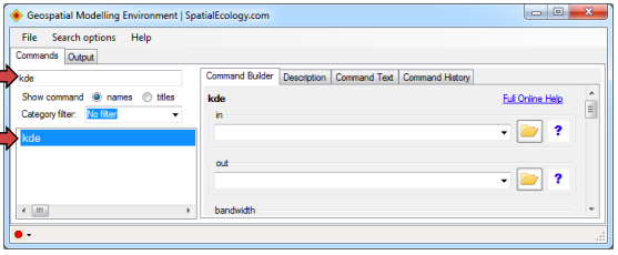
- Run the KDE (kernel density estimator) command in GME. You can access the KDE command by typing “kde” into the command search box, and selecting the KDE command.
- . Input the point shapefile for Animal 1 (i.e., ID_001.shp). [RECALL that the shapefile MUST be in a projected coordinate system.] Specify the output location and SAVE the output with an *.img extension. Use LSCV for bandwidth estimation [see Horne and Garton (2006) article for justification of using this method]. Specify an appropriate cell size. For instance, if you were analyzing selection of vegetation classified from Landsat TM imagery, you might consider selecting a cell size of 30 m to be consistent with the resolution of Landsat imagery. Appropriate cell size should be based on the ecology of the species you are studying and the resolution of the spatial data you are using for the home range analysis. Once all inputs are specified, click “Run”.
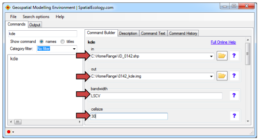
- Once the command has run, you may wish to record the x variance, y variance, and xy covariance values of the bandwidth. This information will be displayed in the “Output” tab.
If you would like to compute isopleths, then you MUST NOT CLOSE GME!!!! OTHERWISE ISOPLETHS WILL NOT RUN and you will have to re-do all the KDEs
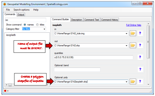
- Run the ISOPLETHS command in GME. Input a KDE file. The name of the output file MUST BE as short as possible (e.g., 4 characters) otherwise the tool will not run. Specify desired quantiles (e.g., 50%, 75%, 90%, 95% percent volume contours). The format of the input code for quantiles should be as follows: c(0.5,0.75,0.9,0.95). If you would like a polygon shapefile created in addition to a line shapefile depicting the isopleths, you must specify that you would like optional polygons created. The polygon shapefile will be useful for computing area of the home range and each quantile. In the example below, the polygon shapefile of isopleths is named 0142isopleth.shp. Once all inputs are specified, click “Run”.
- TROUBLESHOOTING: creating isopleths seems temperamental at times. If you get an error message, try saving the shapefiles in a different folder.