4 Research Sites
Learning Objectives
This chapter will introduce you to the research sites in the West MI Watersheds Database. We will:
- Introduce the Social Science lab and community partners involved in watershed research.
- Review the geographic and social settings of the research sites.
- Describe management goals informing survey design for each watershed.
The West MI Watershed Database and You
In the previous chapter, we examined how social science data is being integrated into watershed management plans developed by organizations across the Great Lakes Basin. The Social Science Lab is an applied research center at GVSU that assists community organizations engaged in stewardship efforts with incorporating local knowledge into the plans and priorities that drive their work.
From 2020-2023, the Social Science Lab conducted seven surveys with five different community partners to inform watershed planning. Phew! We dubbed this collection of survey data from landowners in watersheds up and down the eastern Lake Michigan shoreline the “West MI Watersheds Database.” Each watershed in the database had different management challenges and each partner had different management goals. Additionally, different undergraduate student researchers were employed throughout the projects, each with different research interests. Therefore, the seven surveys had some commonalities and some distinctions.
A few years ago, we decided that the data collected to inform our partners’ watershed management plans could provide a hands-on educational opportunity for GVSU students to practice introductory-level quantitative data management, analysis, and reporting. Hence the class in which you are now enrolled!
All of the skills we practice will provide entry-level experience applicable to professional settings where you will one day be asked to create a report incorporating quantitative performance data, customer satisfaction evaluations, stakeholder assessments, budget expenditures and/or projections, and so forth. Our practice with the West MI Watersheds Database will prepare you to slay new data science tasks with confidence in the future – where it counts!
We experience more freedom and fun while learning challenging things when we have some choices about how our learning occurs (Cavanagh, 2023). Therefore, you will have some choices to make about which watersheds you study this semester and which topics you focus on within each watershed survey. Some watershed surveys are more comparable than others, and you may decide that you want to focus on a single watershed or compare data from two different watersheds.
The first step in making these important decisions about your project is to gain familiarity with the research sites from which we have data available to explore.
Where in the Watershed Are We?
The datasets available in the West MI Watersheds Database cover several broad conceptual categories, varying by survey location and the information needs of the community partner sponsoring the project. In this section, we’ll review the partners, purpose, and priorities covered by surveys conducted in each watershed.
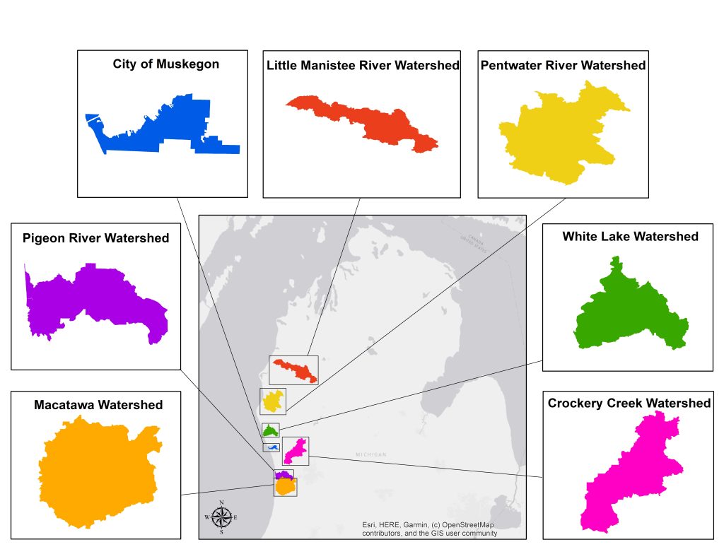
Pigeon River Watershed (PRW)
The Pigeon River Watershed (PRW) stretches across 65 square miles of land in Ottawa County, MI and is a collection of small town and rural communities. The PRW faces management challenges related to NPS pollutants, with E. coli pollution (i.e., fecal contamination) and sedimentation being primary concerns.
In June 2020, the Ottawa Conservation District partnered with the GVSU Social Science Lab to conduct a survey of residential homeowners and farmers in the Pigeon River Watershed (PRW). The goal of the survey was to inform the creation of a watershed management plan (OCD, N.d). We therefore asked landowners about their knowledge of water quality and sources of water pollution, use of BMPs for protecting water quality, and interest in participating in future cost share programs. The survey was mailed to 900 property owners in the PRW. A total of 300 completed responses were received.
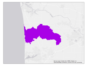
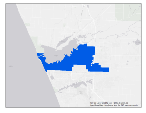
The Lake Macatawa Watershed (MAC)
The Macatawa Watershed (MAC) encompasses 175 square miles of land in Ottawa and Allegan Counties and is characterized by diverse land uses, including intensive residential/commercial development and agricultural operations. The watershed is plagued by high levels of phosphorus pollution from fertilizer runoff and wetland loss that contribute to algal blooms and render the lake hypereutrophic (Iavorivska et al., 2021).
In January 2021 the Project Clarity partners worked with the GVSU Social Science Lab to survey Macatawa Watershed residents about water quality and sources of pollution in the watershed, property management practices, general knowledge about the watershed, willingness to pay for water quality improvements, and participation in Project Clarity initiatives. The survey was mailed to 1,200 property owners in the Macatawa Watershed. A total of 327 completed responses were received.
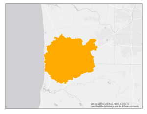
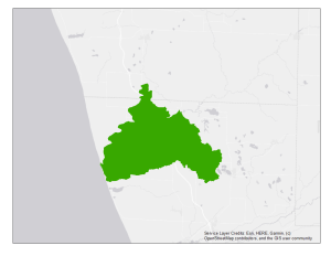
Crockery Creek Watershed (CCS)
Crockery Creek is the largest tributary to the Lower Grand River watershed, serving as the drainage basin for 102,318 acres of predominantly agricultural land in Muskegon, Ottawa, Newaygo, and Kent Counties. Crockery Creek has historically had problems with erosion, which is concerning because sedimentation raises water temperatures and creates a threat to habitat in this treasured local coldwater trout stream. Additionally, fecal contamination is a persistent problem in the watershed, with Crockery Creek having a total maximum daily load (TMDL) target for E. coli bacteria dating back to 2003 (LGROW, 2010).
The Crockery Creek Speaks (CCS) survey was conducted from June – August, 2022 as part of the Ottawa Conservation District’s Crockery Creek and Sand Creek restoration project. This community survey gathered input from rural residents and farmers living in the Crockery Creek watershed about their thoughts on the status and management of local water quality, as well as the accessibility of recreational activities along the creek and residents’ values of wetlands. The survey was mailed to 2,500 property owners and 323 completed questionnaires were returned.
Muskegon Lake Area (MML)
Muskegon Lake is a 4,149-acre drowned river mouth lake on the eastern shore of Lake Michigan and was designated as a Great Lakes AOC. Today, all BUIs have been removed or are in process of removal and the lake is expected to be delisted as an AOC in the near future (US EPA, N.d.). With this exciting milestone on the horizon, interest in preserving public access during recreation and redevelopment is coming to the forefront for community groups.
In March 2021 the Muskegon Lake Watershed Partnership and the West MI Shoreline Regional Development Commission partnered with the GVSU Social Science Lab to survey City of Muskegon residents about recreational activities at Muskegon Lake, perceptions of the lake’s AOC restoration, and satisfaction with features at lakeshore public access sites. The My Muskegon Lake (MML) survey was mailed to 1,860 households. A total of 294 completed responses were received.
White Lake Area (MWL)
White Lake is a 2,571-acre drowned river mouth lake and a former Great Lakes AOC that was delisted in 2014. The area includes two small cities, Whitehall and Montague, and rural farmland. With all BUIs restored and many redevelopment project completed, White Lake is a popular tourist destination (US EPA, N.d.).
In May 2021, Rylie Dorman (GVSU NRM alumna) received a Student Summer Scholar’s award to conduct an independent study of perceptions of lakeshore restoration and recreational use among residents in the White Lake Area. The My White Lake (MWL) survey was distributed to 1,200 households from June – August. In total, 319 completed surveys were returned. Dorman’s comparison of MWL and MML survey results was published in the Journal of Great Lakes Research (Dorman et al., 2023). Go Rylie!
Little Manistee River Watershed (MAN)
The Little Manistee River watershed serves as the drainage basin for 145,280 acres of land in Lake, Manistee, Mason, and Wexford Counties. The “Little River” is valued for its abundant trout and steelhead fish, spectacular scenery, and exciting canoeing (LMWCC, 2022). Steelhead eggs from the Little Manistee are harvested by the Michigan Department of Natural Resources (DNR) to stock rivers across the state (Bullen, N.d). The watershed is sparsely populated, with small villages dotting a landscape of forest and farmland until the river reaches Manistee Lake and the City of Manistee.
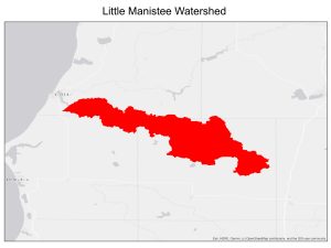
The Little Manistee Management Survey was conducted by the Social Science Lab on behalf of the Little Manistee Watershed Conservation Council (LMWCC) to gather input from watershed residents on local water quality and a proposed DNR Natural Rivers Program designation for the Little Manistee River. The survey was mailed to 1,503 property owners and stakeholders in the Little Manistee River watershed from July-September 2023. We received completed questionnaires from 531 respondents.
Pentwater River Watershed (PENT)
The Pentwater River watershed contains 166 square miles of land in Oceana and Mason Counties. The surrounding landcover is a mix of farmland and forests. The North Branch of the watershed has historically had high quality water resources, with large wetland areas providing habitat for a healthy fishery and abundant wildlife (Pentwater Lake Association, n.d.).
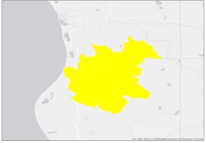
The Social Science Lab conducted the Pentwater Watershed Planning Survey on behalf of the Friends of the Pentwater River Watershed (Friends), from November-December 2023. The purpose of the survey was to assess landowner knowledge, attitudes, and property management actions related to water quality to inform updates to the watershed’s management plan. The survey was mailed to 850 property owners in the Pentwater River watershed. We received completed questionnaires from 168 landowners.
Summary
This description of the unique geographic features and primary land uses of research sites in the West MI Watersheds database will help you decide on the location(s) to focus on in your analysis. Additionally, the background information we reviewed about the project partners for each survey and the management goals for which they were seeking information will help you understand the methods and measures used to conduct the survey. It is to these topics that we turn next.
References
Bullen, W. H. N.d. The trout streams of Michigan: The Little Manistee River. Michigan Department of Natural Resources, Institute for Fisheries Research Archive. Retrieved November 17, 2023 (https://quod.lib.umich.edu/f/fishery/4986997.0074.002?rgn=main;view=fulltext).
Cavanagh, S. R. (2023). Mind over monsters: Supporting youth mental health with compassionate challenge. Beacon Press.
Dorman, R., Buday, A., Woznicki, S., DeVasto, D., and Fergen, J. (2023). Great Lakes for whom?: Community outcomes in the Muskegon and White Lake Areas of Concern. Journal of Great Lakes Research, 49(5): 1166-1178 (https://doi.org/10.1016/j.jglr.2023.07.008).
Iavorivska, L., Veith, T. L., Cibin, R., Preisendanz, H. E., & Steinman, A. D. (2021). Mitigating lake eutrophication through stakeholder-driven hydrologic modeling of agricultural conservation practices: A case study of Lake Macatawa, Michigan. Journal of Great Lakes Research, 47(6), 1710–1725, https://doi.org/10.1016/j.jglr.2021.10.001.
Lower Grand River Organization of Watersheds. 2010. Crockery Creek. Grand Valley Metropolitan Council. Retrieved March 8, 2023 (https://www.lgrow.org/crockery-creek).
Little Manistee Watershed Conservation Council. 2022. History. Retrieved November 17, 2023 (http://www.lmwcc.org/aboutus/history/).
Ottawa Conservation District. (n.d.). Pigeon River watershed management plan. Retrieved December 22, 2024 (https://ottawacd.org/pigeon-river-watershed-management-plan/).
Pentwater Lake Association. (n.d.). Pentwater watershed. Retrieved December 22, 2024 (https://www.pentwaterlakeassociation.com/pentwaterwatershed).
U.S. Environmental Protection Agency. (n.d.). Muskegon Lake AOC. Retrieved December 22, 2024 (https://www.epa.gov/great-lakes-aocs/muskegon-lake-aoc).
U.S. Environmental Protection Agency. (n.d.). White Lake AOC delisted. Retrieved December 22, 2024 (https://www.epa.gov/great-lakes-aocs/white-lake-aoc-delisted).
A place at GVSU for students and faculty to engage in social science research. Learn more here: https://www.gvsu.edu/socialsciencelab/.
Data expressed as numbers.
The geographic locations serving as the focus of research. (Not to be confused with "cite" - a citation for a bibliography list.)
