3 Social Science in NPS Management
Learning Objectives
This chapter will review modern sources of pollution impacting the Great Lakes Basin and how associated management challenges can be informed by social science research. Specifically, we will:
- Distinguish point source from nonpoint source water pollution.
- Define recommended management practices for protecting water quality.
- Evaluate the role of social science research in monitoring and protecting the Great Lakes.
What are Point and Nonpoint Sources of Water Pollution?
In the previous chapter, we reviewed legacy pollution in the Great Lakes that has been caused primarily by point source pollutants. These are water impairments that can be traced to a single, clearly identifiable source, like a wastewater discharge pipe. Entities like factories, city wastewater treatment plants, and large confined animal feeding operations can apply to state environmental regulatory agencies, (i.e., the Michigan Department of Environment, Great Lakes, and Energy, or “EGLE”) for a permit to discharge a regulated amount of treated wastewater to a surface water body (MI EGLE, n.d.). Permit holders are then subject to monitoring and can be fined if they are found to be releasing a higher concentration of pollutants than legally permitted.
While it is an imperfect system, regulatory mechanisms like wastewater discharge permits make point source pollution more manageable than in the pre-1970s era when unregulated industrial waste products, freely dumped into the Great Lakes, created the legacy pollution sites now managed by the Areas of Concern program. While it may often feel like the planet today has never been in worse condition, surface water quality has actually greatly improved thanks to regulatory enforcement and pollution remediation, which – by the way – has cost American and Canadian taxpayers hundreds of millions of dollars over the past thirty years. Ouch!
Today, nonpoint source (NPS) pollutants remain the most vexing form of water pollution from a management perspective. NPS pollutants from stormwater washing off of buildings, across streets, yards, and farm fields, and carrying pollutants into tributaries of the Great Lakes from dispersed sources are a serious management challenge (US EPA, 2024).
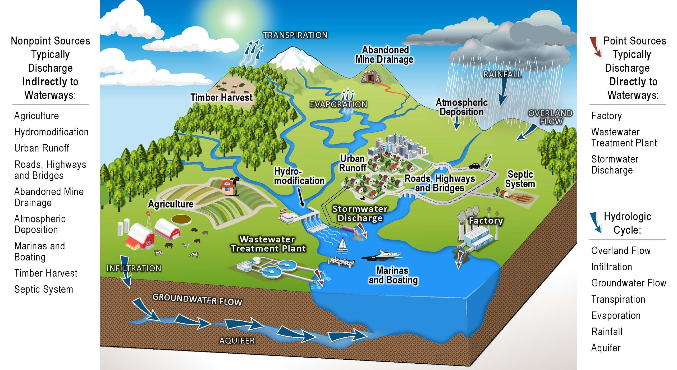
NPS pollution is exacerbated by urban development, which increases impervious surfaces that do not allow water to infiltrate, or pass through the soil to underground aquifers. Hardened surfaces speed up the flow of rain water and snowmelt, increasing erosion and washing litter, motor oil, household chemicals, baby diapers, or anything else in the path of flowing water right into a storm drain. Learn more in the Groundswell video, Communities for Clean Water.
To understand the consequences, we need an infrastructure crash course. It used to be (and in many small towns, it still is the case) that the pipes carrying stormwater from storm drains along roadways and sidewalks were combined with pipes carrying wastewater from sewage lines. Contents of both were co-mingled and traveled to wastewater treatment plants, where they were filtered and treated to remove harmful chemicals and bacteria before being discharged to a nearby surface waterway. Sounds nice, right? Except for when it REALLY rains. Large volumes of stormwater can overwhelm combined sewer systems, causing them to overflow and discharge excess contents – including raw sewage – directly to ground and surface waters. Gross.
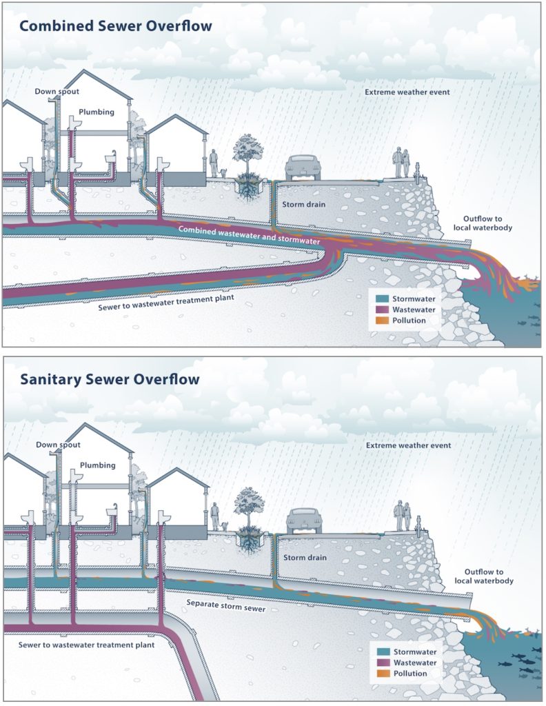
In modern municipal sewer systems, storm drains are separated from wastewater pipes to prevent sewer overflow and reduce raw sewage discharges. However, in these modern separated systems, the contents of storm drains are redirected from wastewater treatment facilities, instead discharging directly to surface waterways without being treated. That slow anti-freeze leak in your car, the plastic food wrapper you tossed out a window, the dog poop pile you left on the sidewalk – all of these NPS pollutants can be carried directly to a surface water body by the next rain storm.
Will You Care a Whole Awful Lot?
Unlike point sources, which can be regulated at their source, managing NPS pollution requires collaboration from everyone because it involves water flowing across multiple areas into a common watershed. A watershed encompasses the area of land that drains into a common body of water, as well as the body of water itself (LGROW, N.d). Watersheds can also be subdivided into smaller subwatersheds that flow together to form larger sub-basins and river or lake basins (Groundswell, N.d).
“Watersheds are a reminder that natural processes do not follow political boundaries and planning for healthy environments can transcend the abilities of individual jurisdictions” (Chester Twp. Master Plan).
Management of Great Lakes water resources is an inherently collaborative endeavor. More than 30 million people in eight U.S. states and one Canadian province call the Great Lakes Basin “home.” Those people contribute pollutants to the Great Lakes system through a wide variety of mundane actions and inactions, every day.
The consequences of water pollution flow along downstream, impacting other communities far from their source. In the Great Lakes basin, the following negative impacts of NPS pollution have been a focal point of NPS management efforts:
- Sedimentation occurs when excessive soil containing clay, silt, and fine organic and inorganic matter enters a water body due to erosion. This results in suspended particles that contribute to turbidity, preventing sunlight from reaching aquatic plants, clogging fish gills, choking organisms, raising water temperature, and interfering with fish spawning. What a mess!
- Nutrient loading occurs when fertilizers containing nitrogen and phosphorus, which help plants grow, are applied excessively or closely to a shoreline, and run off into a nearby water body. Once in the water, the nutrients feed algae, causing it to grow rapidly. Large amounts of algae reduce oxygen levels as they die and decompose, compromising water quality and causing fish kills.
- Bacterial pathogens, such as E. coli bacteria, can cause disease to humans and animals, making them a serious health threat. Bacterial pathogens are typically introduced to waterways through untreated wastewater or raw sewage discharges, as well as from farm fields treated with manure applications or where many animals are closely confined.
Multiple efforts are underway to develop strategic approaches to environmental education and public outreach (USGS, N.d.), with the ultimate goal of increasing the use of conservation management techniques on private properties owned by thousands of landowners.
Watershed Planning: A Role for Social Science
A watershed management plan identifies threats to a watershed and lays out a comprehensive action plan for managing those threats given the contextual features of the watershed.
Watershed plans account for hydrology and soil type, aquatic biology and habitat, water chemistry, infrastructure, population and land use, as well as human behaviors.
- Test your soil before fertilizing to better understand your needs. Use phosphorus-free products and follow the manufacturer’s directions.
- Don’t dump anything down a storm drain.
- Wash your car on a grassy area, use soap sparingly, or take your car to a car wash where the water can be recycled.
- Make sure your car is working properly and not leaking fluids.
- Pick up after your pet(s)!
- Have your septic system pumped every 3-5 years.
- Plant/maintain vegetation on erosion prone areas – especially the banks along rivers, ponds, and lakes.
- In cropping systems, consider using reduced or no-till methods to minimize soil disruption. Consider planting cover crops after harvest to protect the soil surface.
- Restrict livestock access to shorelines to reduce erosion and provide an off-stream watering source to prevent livestock from depositing manure in waterways.
Among practitioners, regulators, and scholars involved in the management of water resources, there is a growing call for the integration of social science research with natural science monitoring of water systems. Several models have been developed to standardize data collection across the Great Lakes Basin. Among these, the Social Indicators Planning and Evaluation System (SIPES) measures social indicators of conservation management (Genskow and Prokopy, 2011). This provides information about watershed residents’:
- Awareness of threats to water resources
- Attitudes about the importance of conservation practices
- Capacity to implement best management practices
- Barriers that prevent them from doing so

This information is used in watershed planning to learn about people’s understanding of their impacts to water resources, and develop outreach and education plans that bridge knowledge gaps and frame the importance of conservation behaviors in terms that resonate with a particular community’s water values.
Summary
Managing nonpoint source water pollution is complicated by the diversity of contributing sources and therefore requires collaboration between multiple entities. Watersheds span geopolitical boundaries, adding another layer of complexity to this work. Watershed planning utilizes a variety of data to identify threats and develop a strategic management approach, but can result in a proliferation of incomparable data if not coordinated. Social Indicators are standardized survey questions that help create consistency in social science data collection and analysis across the Great Lakes Basin.
References
Genskow, K. and Prokopy, L. (eds.). (2011). The Social Indicator Planning and Evaluation System (SIPES) for nonpoint source management: A handbook for watershed projects. 3rd edition. Great Lakes Regional Water Program. (104 pages).
Groundswell. (N.d) Watersheds and nonpoint source pollution. Lower Grand River of Watersheds. Retrieved August 23, 2023 (https://www.gvsu.edu/groundswell/lesson-1-watersheds-and-nonpoint-source-pollution-basics-129.htm).
Lower Grand River Organization of Watersheds, (N.d.) What is a watershed? Retrieved August 23, 2023 (https://www.lgrow.org/watersheds).
Michigan Department of Environment, Great Lakes, and Energy. (N.d). MiEnviro Portal. Retrieved December 19, 2024 (https://mienviro.michigan.gov/ncore/external/home).
U.S. Climate Resilience Toolkit. (N.d.). Heavy rains and stormwater systems. Retrieved December 22, 2024 (https://toolkit.climate.gov/image/3494).
U.S. Environmental Protection Agency. (2014) Polluted runoff: Nonpoint source (NPS) pollution. Retrieved December 19, 2024 (https://www.epa.gov/nps).
U.S. Geological Survey. (N.d.). Nonpoint source pollution impacts. Great Lakes Restoration Initiative. Retrieved December 22, 2024 (https://www.usgs.gov/special-topics/great-lakes-restoration-initiative/science/nonpoint-source-pollution-impacts).
Water pollution that has a single, identifiable source.
Water pollution that comes from numerous, diffuse sources.
Hardened surfaces, like parking lots, that do not allow water to pass through the Earth's surface into soil or groundwater.
An area of land that drains into a common body of water.
Actions watershed residents can take to reduce water pollution.
Standardized survey questions that provide social science data for use in watershed planning.
